Survivalist Forum banner

Tsunami warning : California and southern Oregon.

1.2K views 24 replies 14 participants last post by  UKnorth  
#1 ·
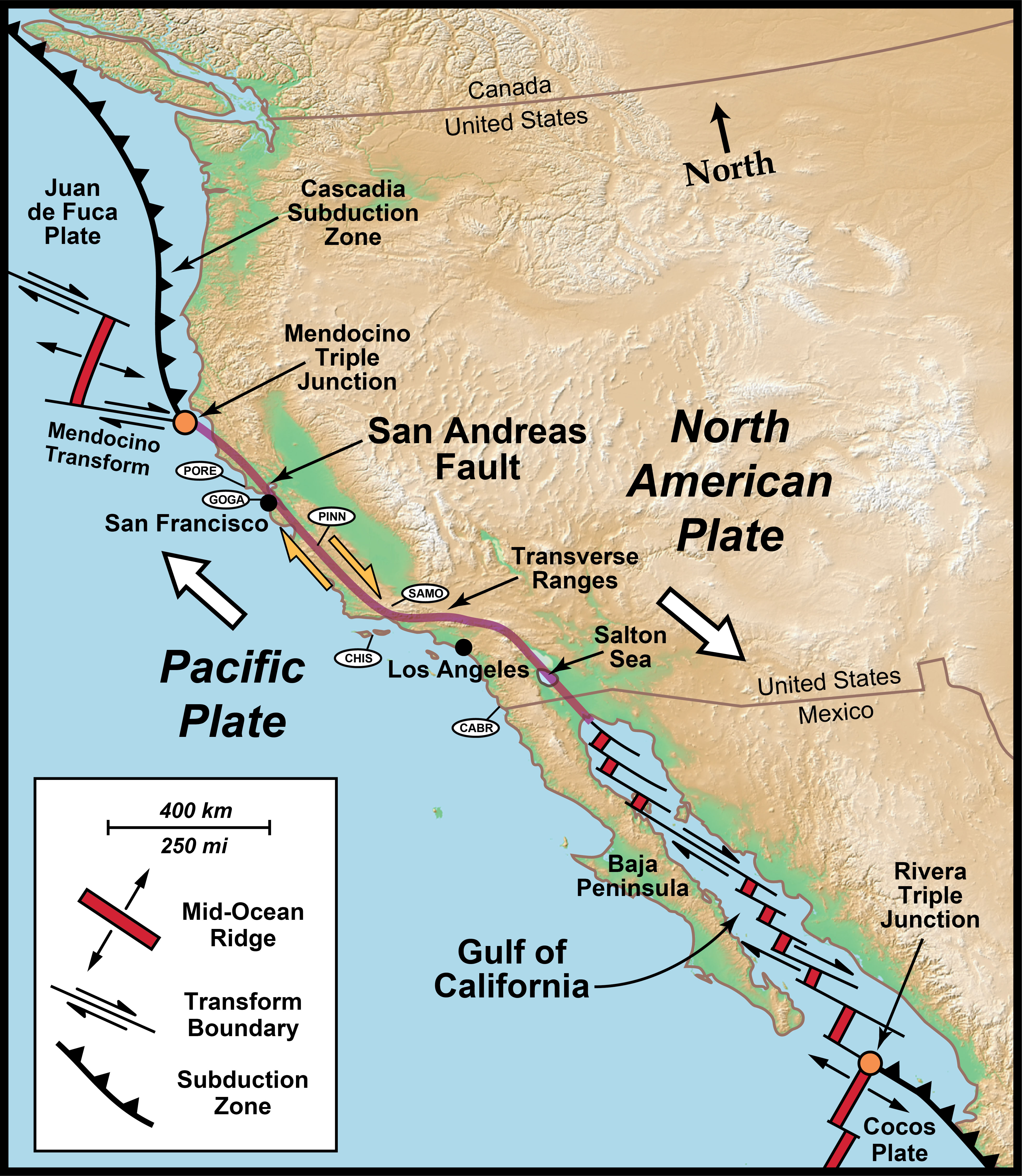
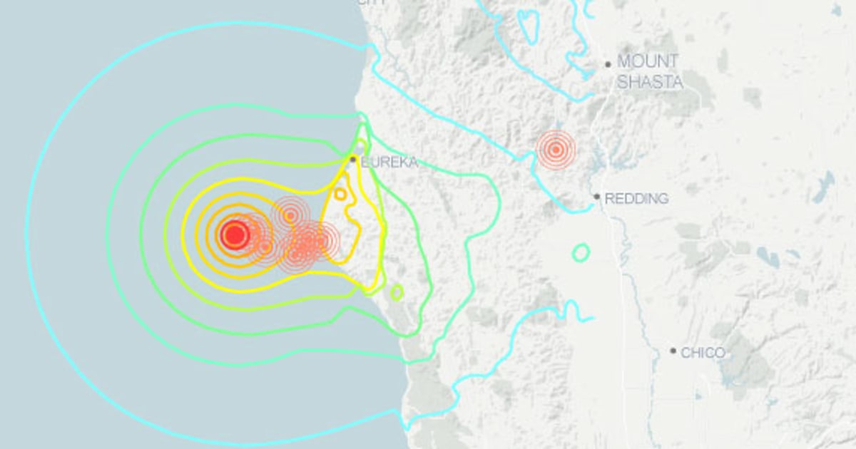
Magnitude 7 earthquake off the coast of northern CA.

Tsunami warnings triggered in California and Oregon after 7.0-magnitude earthquake

The National Weather Service issued the warning for Northern California and parts of southern Oregon after the quake was detected off the coast of Ferndale, California.


Live:

 
#2 ·
#7 ·
Well that is my neighborhood and there were two different earthquakes. On on shore near Petrolia 6.5, and one off shore 7.0 near the "triple junction" of tectonic plates. I actually received a cell phone warning about 5 seconds before the movement started.

This is what some of us have been thru before - look at the series of the April 1992 earthquakes which included a 7.2 magnitude in the same area.


Yeah it's Wikipedia, but easy for some here to understand...


The 3rd earthquake in April 1992 of 6.4 at 4:30am, I was underground in the Humboldt County Sheriff's Office OES underground cold war era bunker command post. I now know how an earthworm feels being fug up from that experience.


Some of us are as prepared to assist others, when natural or man made disasters occur - even here in far North Western Coastal California among the redwood trees.

At 2,000 feet in elevation above mean sea level, I don't worry about being in the Tsunami Zone.


They have changed the looks of our ID cards over the years... This is from being an Advanced Class Amateur Radio Operator for almost 48 years now, and assisting the Humboldt County Sheriff's Office OES, and The State of California Governor's Office of Emergency Services. That ID card would get me thru most roadblocks, in an emergency.


#9 ·
That's the "Mendocino triple junction" and largish quakes are a pretty regular occurrence around there since the 1990's . There was a 6M+ onshore a few years ago. I remember there was bunch of biggies (7M+) in the early 1990's that did a lot of serious damage onshore. That was the first time I heard of places like Petrolia.

I lived for a while one block from the edge of one of the "tsunami evacuation zones" in the Bay Area. The NorCal / PNW plates can generate moderate size tsunamis but nothing really big. At least in California. A few feet max for most of the shoreline. For a really big tsunami (up to 20/25 feet) you need a very big Alaskan earthquake. Like the 1964 M9.1 that generated a 20+ foot tsunami in Crescent City, CA. Which killed a few dozen people. But further south like the Bay Area the worst case scenario is only around 6 feet max. Still a serious flooding risk for shoreline property.

Now when the Cascadia fault pops with its once every 300 years Really Really Big One there are a whole bunch of costal towns in OR, WA and BC that are looking at some serious tsunamis. Multi tens of feet. But unlike tsunamis from any very big Alaska quakes there will be no several hours warning. As little as 10 mins for some towns in OR. So the sooner that OR and WA get something like the MyShake App the better.

The other risk from the Cascadia fault "Big One" are sieches. Basically the lake equivalent of a tsunami. One number I've seen is the predicted max height of sieche on Lake Washington in Seattle after a Cascadia Big One is over 6 feet. Which would do very serious damage to a lot of (very expensive) lake shore property but I think both sets of floating bridges should survive. Although I have my doubts about the new 520 bridge...
 
#11 ·
So was the warning put up just because there was an earthquake but no actual evidence? In my area of the midwest in tornado alley, I have noticed an great increase of tornado warnings based on radar without ever being one on the ground. When I was growing up, a tornado have to have been confirmed on the ground before a warning would go out. I fear that technology and the culture of hypersafety is calling out warnings without actual evidence so often that people will start ignoring them. Maybe they need something between a watch and warning. Watch, then suspected tornado then confirmed tornado?
 
#14 ·
Once the USGS logs an earthquake above a certain magnitude on particular just offshore faults (200/300 miles) that have a real potential to generate a significant tsunamis its an automatic full tsunami alert because there is not enough time to analyze the initial data in the few minutes before any potential large wave landfall. Even if the earthquake only amplifies sneaker waves for a short period of time that's enough to kill people at the shoreline. There a have been a number of sneaker wave warnings the last few weeks but these waves still end up killing at least a few people every year walking on and around the shoreline.

For Alaska quakes the USGS have a lot more time to do analysis of tsunami potential in the Lower 48 so the initial alert is just so people will pay attention. If the reports from coastal Vancouver Island in BC are of serious rises in water height / large inundations then the USGS will upgrade the alert to a full tsunami warning for the West Coast. The same goes for huge earthquake's in Japan, Samoa, New Zealand etc which can potential generate noticeable increases in coast water levels. Which is important to people less than 10 feet above mean high tide. The water levels rise from the Tonga quake in 2022 did serious damage to marinas and harbours in places like Santa Cruz But in those cases it takes many hours (6 to 10 at least) before water levels might rise on the West Coast.

The fault systems around the Mendocino triple junction and those parts of the Gorda and Juan De Fuca plates dont seem to have much of a recorded history of serious tsunamis due to the orientation of the faults etc but large earthquakes can trigger very large underwater landsides which can generate very large tsunamis. Think of them as underwater versions of the huge landslide into a Lituya Bay in Alaska during a 1958 earthquake when half a mountain fell into the water which generated a tsunami that reached the 1700 foot tree line on the maintains surrounding the bay as the water headed for the sea. The largest known submarine slides tsunamis happened around 8000 years ago off the coast of Norway which generated tsunamis estimated at 80 feet plus over a very wide area which seems to have been a major factor in the land bridge (Doggerland) between the UK and mainland Europe now being underwater. Of course if the Great Crack on the Big Island of Hawaii ever develops into yet another major landslide / submarine slide then all bets are off for the West Coast. We are talking the Biggest Ever Wave of Big Wave surfing.

So if in coastal North Coast of CA, OR and WA if any warning comes in just move to higher ground immediately. It unlikely to be a tsunami but one day it will be. Its just like with earthquakes. If the ground starts shaking (or MyShake goes off) you dont hang around waiting to see if its just another tremor or something more serious. By the time you find out its actually something big its going to be too late to dive for safe cover. Another case where Normalcy Bias can get people hurt / killed.
 
#13 ·
So was the warning put up just because there was an earthquake but no actual evidence? In my area of the midwest in tornado alley, I have noticed an great increase of tornado warnings based on radar without ever being one on the ground. When I was growing up, a tornado have to have been confirmed on the ground before a warning would go out. I fear that technology and the culture of hypersafety is calling out warnings without actual evidence so often that people will start ignoring them. Maybe they need something between a watch and warning. Watch, then suspected tornado then confirmed tornado?
Could get too complicated to have an in between category. I don't know how they draw the line. They do have basic definitions on their FAQ. It's clear they issue a warning in advance. Would be too late if they wait til it happens. They don't want false alarms, but it's better to be safe than sorry. Any major quake offshore could trigger a tsunami, I guess. I think a tsunami is triggered by an underwater landslide, which can happen on a shallow slope, and that is triggered by an earthquake, which is caused by plate movements.
View attachment 592812
Pretty darn close to the fault line . . .
Yeah, close to that triple junction
Image
 
#16 ·
Talking about other tsunamis, volcanic islands are a source, where a chunk of the volcano slips into the sea. The 2018 Sunda Strait tsunami was the most recent one. La Palma is a well known one, as it used to be believed it could travel all the way to America (this is now debated). It could collapes in stages, causing smaller tsunamis.

The 2004 Indian Ocean tsunami was one of the deadliest disasters in human history, with 230,000 killed or missing. It was generated by a megathrust earthquake at a convergent plate boundarty, a subduction zone. The slip took place in two phases over several minutes. The second phase occurred further north on a strike/slip fault. There was 10 m movement laterally and 4–5 m vertically along the fault line. 1,500-metre-high thrust ridges created by previous activity along the fault had collapsed, generating landslides several km wide. One such landslide consisted of a single block of rock 100 m high and 2 km long. The momentum of the water displaced by tectonic uplift had also dragged massive slabs of rock, each weighing millions of tonnes, as far as 10 km across the seabed. The area had not been considered high risk. Things have been learned about the geology that can cause tsunamis. Obviously the warning system was also needing improvement. Basically there weren't any, mainly because tsumanis are not common in the Indian Ocean.
 
#19 ·
Talking about other tsunamis, volcanic islands are a source, where a chunk of the volcano slips into the sea. The 2018 Sunda Strait tsunami was the most recent one. La Palma is a well known one, as it used to be believed it could travel all the way to America (this is now debated). It could collapes in stages, causing smaller tsunamis.
La Palma is a maybe for the East Coast of the US but the Big Island of Hawaii is a definite for the West Coast. But it is of the order of many 100K's of years.

Nice explanation here


I know if I was somewhere like San Francisco when I heard that there are initial news reports of a huge coastal landslide in Hawaii, that a large chunk of the Big Crack fell into the sea, I'm loading up my car with all the emergency supplies I can carry and I'm up to the top of Twin Peaks or Mt Davidson, or even better Mt Tam or Mt Diablo (other mountain tops will work), and then wait to see how the situation develops from the highest elevation I can find. I wont be happy unless I'm over a 1000/1500 feet elevation.

Although the physics of the earthquake tsunami in the movie for San Andreas was totally wrong, just silly, if the Big Crack ever delivers a good sized chunk of the Big Island into the Pacific the CGI wave in the movie might be not that far off reality by the time it reached the inshore continental shelf. The bridge deck is 300 feet above sea level so a 350/400 foot wave looks doable.

Image


Now the Monterey Bay area, that is totally screwed. It will get the full force of the wall of water without any shallow sea-floor drag reducing energy. As will parts of the North Coast around Eureka. But its a once in many 100K years event risk. So very very low on the list of things to worry about. At least in California you are at a far higher risk of being maimed / killed by some bone-headed thing CARB or CalEPA does. They do so many.
 
#18 ·
Funny someone mentioned not feeling the earthquake while driving.

The most common initial response of people who are driving when a really big earthquake hits is they think they just had a blow out. Usually a rear tire. As the car become more difficult to steer. It takes a few second to realize that it was not a blow out. Usually when they see others drivers in front of them starting to veer between lanes on the road.

That was a common story of people I knew who were driving on freeways when Loma Prieta hit in 1989. Those who had not already got home for the start of the ball game. Talk about the third game of the World Series starting with a bang. It had to be postponed due to all power being knocked out.

The strangest driving story I heard was from someone who was driving on the San Rafael Bridge in the North Bay when the earthquake hit. Due to the orientation of the bridge to the San Andreas fault the deck of the bridge rose and fell at least 3 feet while the crests and troughs of the main shock passed. He could see the cars in front of him being bounced up and down as the waves passed. He said it looked like the cars in front were boogie boarding the waves on the deck of the bridge as they passed through . Luckily traffic was very light and there was an extra lane used as a hard-shoulder so everyone was able to stop without any serious accidents. Just a few minor fender benders

There was no real damage to San Rafael and it was the only way to get to and from the East Bay (via the Golden Gate Bridge) for the next month while they patched up the Bay Bridge. The bridge whose upper deck failed when one small deck section got dislodged. Held together by 9 inch bolts for what turned out to be a 12 inch displacement at that part of the bridge structure by the earthquake. A fairly typical story with structure failures during earthquakes. Small out of tolerances / design range failures causing major damage.
 
#20 ·
I felt it way inland from the coast. There wasn't damage here from what I've seen.
[/QUOTE]
I received the warning and a few minutes later I watched the pool water mildly sloshed back and forth but other than that I didn't notice, I'm inland around 75 miles inland from San Fransico. Friend in Clear Lake area felt it and said it was a pretty good shake,
 
#21 ·
A Tidal wave of up to 1750 feet struck Lituya Bay in Alaska in 1958.
The tidal wave that wiped out Valdez in 1964, was appx 170 feet(60ft wave).
One of my shoe string relatives lived near Anchorage during the 1964 earthquake.

Keystone Canyon, a short way from Valdez has evidence of flooding several hundred feet up the canyon walls from the past.

Crescent City had the 30 ft Tidal wave from the Alaska earthquake in 1964
11 died, many of them that died, went down to the jetty to watch the Tidal wave and were swept away